
Seeing what’s happening NOW visually is a key asset in your tools for planning and traveling. Whether it's navigating to your wintry adventure or planning your day, these tips on utilizing the Truckee webcams will help you spend less time in traffic and more time enjoying your trip from start to finish.
How Are The Roads To Get To Truckee?
Truckee sits conveniently along Interstate Highway I-80, providing easy access by car. However, during winter weekends and holidays, traffic can become heavy. Ensure you're ready for potential delays by planning for extra travel time.
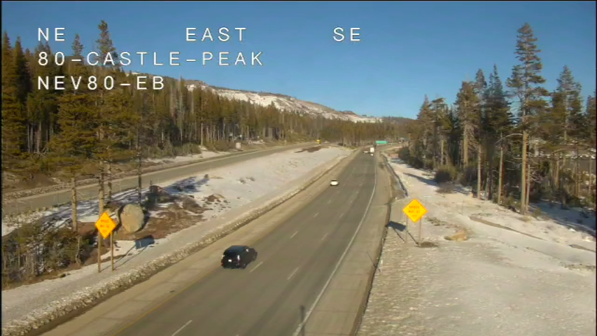
If you're journeying from the Bay Area or Sacramento, check out the I-80 webcams at Kingvale, Soda Springs, Castle Peak, and Donner Summit for live updates. Traveling to Truckee from Reno? Check on I-80 traffic with the Floriston and the Truckee Scales webcams.
What Are Chain Controls And Are There Any?
During snow events, Caltrans may deem it necessary to have drivers stop and put on chains for safety before traveling over Donner Summit. For a detailed breakdown of chain control types and requirements, check out this informative article and chain requirement flyer. If you're traveling on I-80, use the Caltrans Road Information tool and enter '80' to check for chain controls or any road-related issues.
Be Prepared for Winter Driving
Even with ample amounts of planning, accidents and weather can slow the traffic to a crawl quickly. Ensure you have a full tank of gas, carry snow chains, pack some snacks, and keep blankets handy in the car, just in case. Learn how to be prepared by reading these Winter Driving Tips from Caltrans.
Truckee Webcams to Check If It’s Snowing
The million dollar question - does Truckee have snow? On average, Truckee’s climate receives over 200 inches of snow annually. In higher elevations like the High Camp at Palisades Tahoe (elev. 8,200 ft) along the Sierra Crest, snowfall can exceed 500 inches per year or more! February stands out as our snowiest month, with an average of 44 inches of snow. To see if we have snow in town (elev. 5,817 ft), explore our downtown Truckee webcams. Additionally, check the daily Truckee-Tahoe Travel Alert for a heads up on incoming weather and snow for Truckee, California.
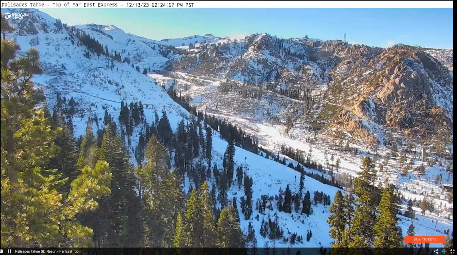
What’s The Weather Like At Truckee Ski Resorts?
Get a glimpse of what the slopes look like before you venture out. Storms in the Sierra are legendary, coming in with gale-force winds and depositing feet of snow in a matter of hours. This may shut down some or all the lifts for the day. And mountain weather is unpredictable, creating microclimates where it may not be snowing in town but it is at one ski resort and just overcast at another. Check out the Ski Resort Webcams from your homebase before setting off.
Getting To Your Favorite Ski Resort
Great, the lifts are spinning and the snow's straight out of a Hallmark Christmas card. Now make sure you can reach your ski resort hassle-free. Stay updated on road conditions and traffic through Caltrans and CHP's Social Media Accounts via: Caltrans Twitter, Facebook, and Instagram, as well as CHP Truckee's Twitter, Facebook, and Instagram. For all the resorts below, if you’re staying in Tahoe Donner, start by checking the Uphill Northwoods cam to see traffic at the Donner Pass Road intersection.
Cams for Driving to Palisades Tahoe & Alpine
To reach Palisades Tahoe & Alpine, you must take Highway 89. If you're coming from Truckee, check traffic conditions on the Hwy 89 and West River Street camera along with the entrance to Olympic Valley. For those arriving from the south, refer to the Hwy 89 and Rampart camera and the Hwy 89 and Alpine Meadows Entrance. While the video cameras offer visual information, don't forget to use the Caltrans Road Information tool and enter '89' to check for any chain controls or road issues.
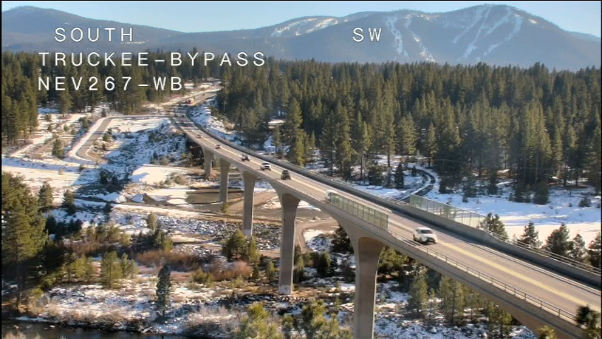
Cams for Driving to Northstar California Resort
For Northstar California Resort, Highway 267 is the main corridor to access the ski resort. If you’re driving to Northstar from Truckee, check the Hwy 267 at Truckee Bypass cam to get a sense of traffic closer to town and the Hwy 267 at Northstar cam (facing north towards Truckee) to see conditions at the entrance to the resort. If you're approaching from the south, you'll pass over Brockway Summit. Check out the camera at Tahoe Vista for a view of the road as it ascends.
Cams for Driving to Sugar Bowl Resort
The most direct route from Truckee to Sugar Bowl Resort is via Old Highway 40, the original connection between Truckee and Tahoe from the Bay Area. On a sunny day, the scenic Donner Summit road is a breathtaking journey. However, during winter storms, this winding road is typically closed until it can be cleared of snow. Or you may encounter chain control where the road begins to wind upwards at the West End of Donner Lake. Stay updated on Old Highway 40's openings and closures by signing up for text alerts - just text 'Old40' to 855-835-5599.
When Old Highway 40 is closed, take I-80 to exit 174 as an alternative route. Check I-80 at Donner Lake cam to see westbound traffic and I-80 at Kingvale to see eastbound traffic to Sugar Bowl.
Cams to Check Before Leaving Truckee and Heading Home Towards The Bay Area
You’ve had a full weekend of fun and now it’s Sunday afternoon. Even if it isn’t snowing, it’s a good idea to check I-80. The webcams to look at include the entrance to I-80 and Hwy 89, I-80 and Donner Lake, I-80 at Soda Springs, the westbound view at Kingvale.
Not All Roads Are Equal
At times, the snow is coming down at such a furious clip that it leads to the closure of I-80, giving Caltrans an opportunity to remove the snow and make the road safe. Alternative routes suggested by your phone often involve two-lane mountain roads that may pose risks, some of which are even unpaved forestry service roads that are left unplowed. Instead, we advise patience and a good podcast while allowing Caltrans time to clear the road. If weather conditions are especially frightful, consider extending your stay for an extra night.
Have A Plan B
Local wisdom often reveals that no matter how early you start or how carefully you plan, sometimes Plan A doesn't pan out. On those days, it's crucial to recognize when to pivot to Plan B. Fortunately, Truckee offers a plethora of enjoyable winter activities! Try cross country skiing or snowshoeing, explore Downtown Truckee, visit Donner Memorial State Park, take a leisurely stroll along the scenic Truckee River Legacy Trail, or for quieter slopes, think about hiring a local guide for a day of backcountry skiing in Truckee-Tahoe.
Don’t want to deal with winter roads during your stay? Explore Truckee riding TART Connect, a free on-demand shuttle that you can use to get around town and to/from your Truckee lodging.