
Inspiration & Stories
Visitor's Guide to Wildfire Season in Truckee-Tahoe
What You Should Know Before Visiting
Truckee-Tahoe's wildfire season is typically late June through November, or after the region receives significant moisture. During this time, be prepared, have a plan, and stay alert during your visit. For daily updates, visit the Truckee-Tahoe Travel Alert. And check out these wildfire webcams to view current smoke conditions.
- Check the Truckee-Tahoe Travel News This Week for updates.
- Sign up for TahoeAlerts - Your One-Stop Emergency Notification System. Simply enter your address or location to sign up.
- Download the Watch Duty App for local and regional wildfire information.
- Check NOAA's weather forecast for a Red Flag Warning alert.
- Driving here? Carry an emergency kit in your car.
- Read the Visitor's Guide to Power Outages to be prepared in the event of a planned power outage (PSOM/PSPS) or wildfire-related emergency electrical shutdown.
- Know your evacuation zone and closest evacuation routes.
Truckee Fire Bans
The Truckee Fire Ban is in effect for Truckee and Donner Summit residential areas. This ban is typically in effect June thru November or until Truckee receives significant moisture. Designated state and federal campgrounds/day use areas and private campgrounds/day use areas with a valid permit are exempt.
- NO WOOD OR CHARCOAL FIRES & BBQs
- Outdoor gas devices are permitted.
- During a Red Flag Warning, all open flames are banned including gas grills.
- Truckee Fire Ban FAQs
Donner Memorial State Park Fire Restrictions
- Camping: Fires permitted in designated camp rings.
- Day Use: Wood and charcoal prohibited in day use areas. Propane/gas grill allowed.
- During a Red Flag Warning, wood and charcoal fires are prohibited.
- Donner Memorial State Park website
Tahoe National Forest Restricted Use Areas: Prosser, Boca, Stampede, Hwy 89
Dispersed camping as well as building, maintaining, attending, or using a fire, campfire, or stove fire is PROHIBITED in Tahoe National Forest "Restricted Use Areas" which include Prosser Reservoir, Boca Reservoir, Stampede Reservoir, and the Hwy 89 corridor south. View maps of Restricted Use Areas (pg. 6-11) and details in FOREST ORDER No. 17-22-06. Order effective now through June 30, 2025.
Understanding Fire Weather and Red Flag Warnings
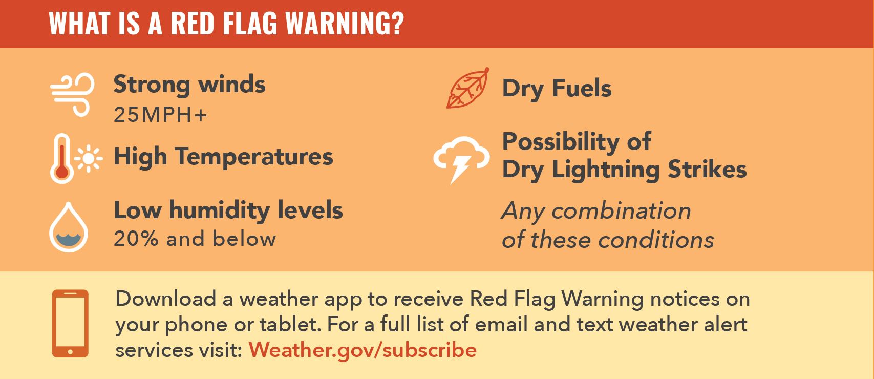
What is a Red Flag Warning?
A Red Flag Warning is issued by the National Weather Service when weather events may result in EXTREME FIRE DANGER. Any combination of the following conditions may trigger a Red Flag Warning:
- Strong winds (25+ mph)
- High temperatures
- Low humidity levels (20% and below)
- Dry fuels
- Possibility of dry lightning strikes
NO OPEN FLAMES. Please take extreme caution during a Red Flag Warning. In Truckee and Donner Summit residential areas, open flames are banned while a Red Flag Warning is in effect. This applies to any type of fire source: gas, wood, charcoal, smoking, etc.
Where can I see if a Red Flag Warning is in Effect?
What is the difference between a Fire Weather Watch and Red Flag Warning?
Fire Weather Watch is issued when weather conditions in the next 12-72 hours could lead to extreme fire behavior. It's a heads up to get prepared, alerting the public that fire conditions are possible but not imminent or occurring.
Red Flag Warning is issued when critical fire conditions are ongoing or expected to occur within 24 hours. Learn more from NOAA's Understanding Wildfire Warnings, Watches.
Learn more about Red Flag Warnings and fire weather.
- Red Flag Warnings & Fire Weather Watches, Truckee Fire Protection District
- Red Flag Warnings, Nevada County
- Understanding differences between fire watch, red flag warnings, ratings, Tahoe Daily Tribune
Where are fires burning? How far from Truckee?
During wildfire season, it is not uncommon to have fires burning in other parts of California with no threat to Truckee, although they may affect air quality. Use these resources to see where active fires are and if they affect the Truckee-Tahoe region:
- CAL FIRE incidents within 100 miles of Truckee: View information about active wildfires under CAL FIRE's jurisdiction that are greater than 10 acres. Fires outside of CAL FIRE’s jurisdiction will also appear but without acreage and containment information.
- InciWeb Map: Web browser map for incidents that occur on federal, state, tribal and local jurisdictions. Includes the Tahoe National Forest.
- Large Wildfire Map: Web browser fire map for the US and Canada.
- Watch Duty: Unofficial service powered by volunteer firefighters, dispatchers, and first responders who monitor radio scanners and other official sources 24 hours a day for the most up-to-date information. Available for Apple, Android, or web browser.
What should I ask my lodging provider?
- What is the address of my lodging? Know your evacuation zone and all possible evacuation routes from your location. Your route will not be identified by authorities until an evacuation is actually happening.
- What county is my lodging in? Truckee and Donner Summit span two counties, Nevada County and Placer County. Know which county your lodging is in so that you can sign up for the appropriate emergency notifications.
- Is there road construction? After reviewing construction updates on the Truckee-Tahoe Travel Alert, you may wish to ask about road construction and how it may impact travel and evacuation routes.
- What is the cancellation policy? Understand your lodging provider's cancellation policy and what your travel insurance will and will not cover.
What should I carry in my emergency kit?
If you are driving to Truckee, learn how to assemble an emergency kit and keep it in your car. At a minimum, your kit should include the following:
- Water
- Snacks
- Flashlight
- Backup power for your phone
- Physical map of Truckee
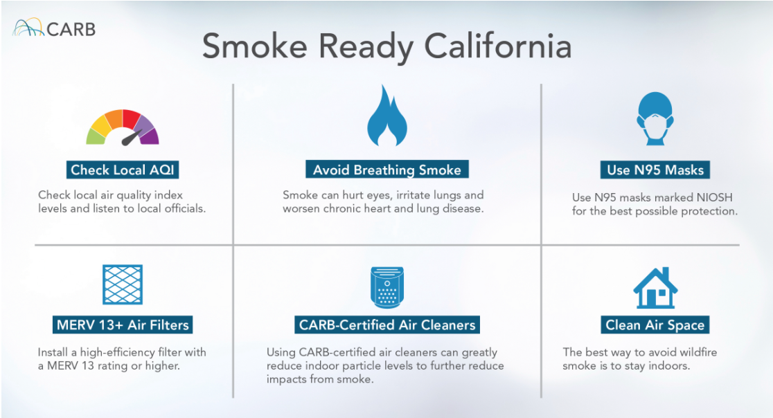
How can I check Truckee-Tahoe air quality?
Check our Truckee weather page for live webcams, air quality readings, and smoke forecast links. Keep in mind that air quality can change quickly with wind shifts or as new fires pop up. Learn about protecting yourself from wildfire smoke from the California Air Resources Board.
Roads & Traffic Information
- Truckee Weather, Roads, Webcams - view our page for traffic information, live traffic cams, NOAA weather forecast, wildfire lookout cams, and more.
- Caltrans Mobile QuickMap - download this app for current highway closures, construction, and collisions. Available for Android and iOS.
- Check Highway Conditions & Status - view current road conditions from Caltrans. For I-80 Road Report – enter 80, Hwy 89 Road Report – enter 89, Hwy 267 Road Report – enter 267.
Social Media Accounts to Follow
- Nevada County Office of Emergency Services
- Nevada County Sheriff's Office
- Placer County Sheriff's Office
- Truckee Fire Protection District
- CAL FIRE Nevada Yuba Placer Unit
- USFS Tahoe National Forest
- USFS Lake Tahoe Basin Management Unit
- Caltrans District 3
- CHP Truckee
- Nevada County
- Placer County
- National Weather Service Reno
Be Prepared for Evacuations
Know your evacuation zone.
Find your Nevada County evacuation zone using Genasys Protect (formerly Zonehaven). Enter the address of your lodging or residence to find your evacuation zone and view its current status - Evacuation Order, Evacuation Warning, Advisory, Clear to Repopulate, Shelter in Place, or Normal.
Identify evacuation routes.
Talk with your lodging provider and ask what the closest evacuation routes are. Print a physical map of Truckee and identify at least three evacuation routes from your location. Ready Nevada County Dashboard Evacuation Route Pre-Planner.
How do I know when to evacuate?
Be familiar with the different evacuation terms - Evacuation Order, Evacuation Warning, Shelter in Place - so that you know what to do if an evacuation warning or order is issued. Evacuation Terms Explained.
Listen for evacuation sirens.
Truckee Police Department's Hi/Lo evacuation siren alerts the community to evacuate now. When you hear this Hi/Lo siren, it's time to GO - evacuate immediately
See Something, Say Something: Call 911
- Don't hesitate to report wildfire safety concerns. CALL 911 if you see billowing smoke, an unattended campfire, an active wildfire that is not attended, or any other immediate threat to life, property, or the environment.
- For non-emergencies, Truckee Police can be reached at 530-550-2320.
Thank you for Recreating Responsibly
Nearly nine out of ten wildfires nationwide are human-caused and can be prevented. We all play a role in preventing wildfires. Please remember to Recreate Responsibly while enjoying the outdoors in Truckee-Tahoe. Know before you go, plan and prepare, build a safe and inclusive outdoors, learn how to respond, respect fire, and make it better. Thanks for helping TAKE CARE of our local Truckee community!
How to Recreate Responsibly - Wildfire Edition
Disclaimer - Information provided on VisitTruckeeTahoe.com (including and not limited to text, video, graphics, audio or photos) is for educational and informational purposes only. Use of information provided on this page or any other VisitTruckeeTahoe.com page is at your own risk. Refer to official government, agency and emergency services websites for official information. Privacy, Terms & Conditions.